Four epic bike rides on the Faroe Islands
- Blu Acciaio Editor
- Aug 3, 2025
- 8 min read
Updated: Aug 7, 2025
The Faroe Islands has been on our bucket list for a long time, as a place we wanted to explore and get to know by bicycle. When the Easter vacation of 2025 lined up perfectly with a weekend and some bridge days, we knew that could be our ticket to ride. Situated in the Atlantic Ocean, midway between Iceland and Norway, the climate on the Faroe Islands can be quite harsh, especially during wintertime. But since Easter in 2025 came late in April, we decided to trust in the saying "there is no time better than now", even if that meant seeing the islands yellow instead of green.
In this blogpost, you'll discover how to reach the Faroe Islands by slow travel and find a guide to some of the best bike rides and routes to explore these amazing islands once you are there.
How to reach the Faroe Islands: Flight vs ferry for cyclists
The most obvious choice to get to the Faroe Islands is perhaps by airplane. But another option is Smyril Line and its ferry MS Norröna. This ferry connects the Faroe Islands, Denmark, and Iceland and runs on a weekly basis from mid-March to the end of November. For Easter 2025, Smyril Line offered a quite appealing package deal, containing ferry transport to and from the Faroe Islands plus hotel accommodation for four nights. Perfect for our timetable and with ample time to explore the islands by bike. It also saved us the hassle of packing bikes into giant cardboxes and dragging them to and from the airport.
Slow travel by train and with Smyril Line across the Atlantic ocean
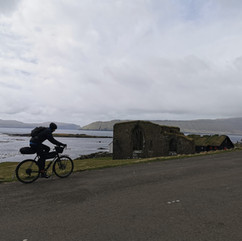
MS Norröna departs from Hirtshals in Denmark. From Oslo, we decided that the best, and most entertaining way, to get to Hirtshals was to take the train from Oslo to Gothenburg, board the Stena Line ferry from Gothenburg to Fredrikshavn, and then cycle from Fredrikshavn to Hirtshals. After all, we were on a cycling adventure. This journey only took two days, with an overnight stay in Fredrikshavn, as the timetables gave us comfortable time to transfer.

Our ride from Fredrikshavn to Hirtshals.
What to expect crossing the Atlantic ocean
The crossing from Hirtshals to Tórshavn takes about 36 hours. Along the way you really get to enjoy the open sea, and also see oil platforms on the horizon, as well as beautiful views of the Shetland Islands. We saw some passengers who had brought binoculars to really catch the views. So if you have space to spare, this could be worth the weight. There are plenty of restaurants aboard MS Norröna. We found it most affordable to book meals in advance. Make sure to bring some medicine for motion sickness, so you also get to keep those delicious meals.


The hotel included in the package deal, Hotel Brandan, was located very close to the harbor and center of Tórshavn, just five minutes away by bicycle. As soon as we arrived and had checked in at the hotel, we went out to explore the roads of the Faroe Islands. We managed to squeeze in four wonderful rides during our stay. You can read about each of these cycling adventures in more detail below. All of them are daytrips.
On our way home from the Faroe Islands, we even found time for a detour to Skagen, at the Northern tip of Denmark. After that, we simply followed in reverse the route we used a week earlier, but took an extra night in Gothenburg. The Scandic Gothenburg Central hotel can be highly recommended. It's close to the central station and has a secure room for storing bicycles.


Our ride from Hirtshals to Fredrikshavn, with a detour up to Skagen and Grenen, at the very North of Denmark.
Guide to some of the best bike rides in the Faroe Islands: four amazing and not too demanding rides
Route 1: Múlafossur waterfall
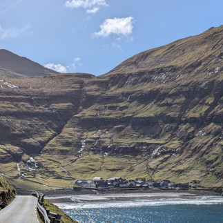
The destination for our first ride was the famous Múlafossur waterfall. This waterfall is located far west, just below the settlement of Gásadalur on Vagar Island, about 11 km from Vagar Airport. A fun fact about this place is that it was only in 2004 that a tunnel made it possible to drive or cycle to Gásadalur. Before that, it was necessary to hike over the mountain.
Getting out of Tórshavn: Two main cycling routes
There are only two main roads cyclists can use to get out of Tórshavn. One is the Kaldbaksvegur (road 10) and the other is Oyggjarvegur (road 50). The latter goes over the mountains north of Tórshavn and has some fierce elevation at the end on both sides. For our first ride, we chose to go along Kaldbaksvegur, which runs along the coast northeast of Tórshavn. This road has a fair amount of traffic and some tunnels, but feels safe and has an acceptable shoulder.
Cycling through Vágatunnilin: Subsea tunnel experience
To get to Vagar Island, you also have to ride through the Vágatunnilin. This tunnel is one of many connecting the Faroe Islands, and is allowed for cyclists. It's nearly 5 km long and will take you about 100 meters below sea level. Don't worry about cycling underwater – just keep your lights on, stay on the shoulder, and keep on trucking. On the other side, a rather steep and long climb awaits that will take you across the mountain, over to Sandavágur. From there, just enjoy the scenery and follow the road to Gásadalur and the waterfall.


Our ride from Tórshavn, via road 10, to the Múlafossur waterfall, and back.
Route 2: Tjørnuvík village via the scenic mountain road
The second day we decided to ride to the small village Tjørnuvík, which is the northernmost village on Streymoy. In 2006 this village had a total population of fewer than 100 people. Tjørnuvík is located on the same island as Tórshavn, so there's no subsea tunnel on this ride.
Discovering the old mountain road: Oyggjarvegur
On the ride to Múlafossur waterfall, we had taken the Kaldbaksvegur out of Tórshavn, so on this ride we decided to check out the Oyggjarvegur as an alternative route. This mountain road used to be the main road north, before Kaldbaksvegur opened in 1992. It goes from Tórshavn to north of Oyrareing. There's now very little traffic on this road, so it's a great choice for cyclists. Riding from Tórshavn, it starts with a rather steep climb of about 9 km and 350 climbing meters. Once up on the plateau, you're rewarded with amazing views of the landscape. But be prepared for swift changes in weather conditions. This is true for all of the Faroe Islands, but particularly when up in the mountains.
Coastal road to Tjørnuvík
After descending the mountain on the other side, we headed slightly south, through Oyrareing, before again heading north, following the Sundalagsvegur on the east side of Streymoy. Just before the bridge to Eysturoy, we took off the main road, onto road 594. This is a single-lane road that runs all the way to Tjørnuvík. It's really beautiful, as it runs in the hillside, with spectacular views of Eysturoy to the east. You can also see the famous Risin and Kellingin sea-stacks towering in the ocean, just before you start the descent down to Tjørnuvík.


Our ride from Tórshavn, via Oyggjarvegur, to Tjørnuvik , and back.
Route 3: Eiðisskarð mountain pass
The third day was perhaps the most ambitious and adventurous day, as we set course for the Eiðisskarð mountain pass, far north on Eysturoy. The weather was considerably worse than the other days, with intermittent showers and quite a bit of wind.
Conserving energy on the way to the mountain pass
Still remembering the nine km climb up Oyggjarvegur, we opted to take the flatter Kaldbaksvegur out of Tórshavn, to save energy for the climbs to come later that day. We then got onto the Sundalagsvegur around Oyrareing and followed the road northeast until it crossed the bridge over to Oyrarbakki on Eysturoy. From there, we kept on road 10 and started to climb up the hillside until we entered the Norðskálatunnilin a bit further up. This tunnel is about 2.3 km long and gave us a welcome break from the weather, which at that time had taken a turn for the worse with snow and strong wind.
Climbing the Eiðisskarð pass
Exiting the tunnel on the other side, we turned north and headed past Funningsfjørður, following the road west of the fjord, until we reached Funningur. This is the start of the climb that leads to the Eiðisskarð mountain pass. Keep in mind that this pass is closed for passage during winter months. After reaching the top, we coasted effortlessly down to Eiði on the other side and enjoyed a fantastic view of the Risin and Kellingin sea-stacks from a new angle. After reaching Eiði, we followed the road back to Oyrarbakki, slightly downhill all the way, and from there took the same route back as we came, several hours earlier.


Our ride from Tórshavn to climb the Eiðisskarð pass, and back.
Route 4: Kirkjubøur cultural heritage site
On our fourth day, which was also our last day on the Faroe Islands, we decided to ride to Kirkjubøur. MS Norröna was leaving in the afternoon, and with its weekly sailing schedule, that's not a departure you'd want to miss. But being only 15 km away from Tórshavn, and with modest elevation, we decided that it would be realistic to reach Kirkjubøur and get back, with some margin for punctures and whatnot.
Exploring the Faroe Islands most important historical site
Kirkjubøur is considered the most important historical site on the Faroe Islands. There you'll find the ruins of the Magnuskirkja (St. Magnus Cathedral) from around 1300, which is the largest medieval ruins in the Faroe Islands. In 1832, a runestone was found there, referred to as the Kirkjubøur stone, and dates back to the Viking Age. So this is definitely a place worth visiting. As with so many other places on the Faroe Islands, there aren't that many tourists around. It really feels special just to walk around, looking at the scenery and listening to the sea and wind. It really gives peace of mind.
The easiest ride
Getting to Kirkjubøur and back is definitely the least challenging of these four rides we took. Simply head north out of Tórshavn until you hit the Markangilsvegur. After a while, you'll see the Kirkjubøarvegur (road 12), which will take you all the way to Kirkjubøur. There's just one small hill you have to climb along the way. On our way back, we also found time to explore the streets of Tórshavn, with its harbor and small cafes.


Essential Tips for Cycling the Faroe Islands
Weather and Clothing: The Faroe Islands have an oceanic climate with cool summers (average 13°C) and mild winters (average 3°C). But it's not the temperature that its the most challenging, it's the wind and rain. The weather can change quickly, so no matter how it looks when you head out, be sure to pack something to protect you against rain and wind, and always bring an extra pair of gloves. May through September are probably the most forgiving months to cycle the Faroe Islands.
Tunnel Safety for Cyclists: Most tunnels scattered around and between the Faroe Islands are open to cyclists. Be sure to use both head- and tail lights, as some of these tunnels can be quite dark. Also, there are a couple of tunnels that are closed to cyclists. To our knowledge, those are the newer tunnels Eysturoyartunnilin and the Sandoyartunnilin. We heard about a shuttle bus for cyclists through these tunnels, but didn't investigate it further.
Bike Maintenance and Supplies: Bike shops are few and far between, so remember to bring spare parts for your bike, at least an extra chain, a gear cable and some tubes.
Food and Water: While there are quite a few villages throughout the Faroe Islands, only some of those have grocery stores, so make sure to stock up with chocolate, bread, and water when you can.
Transportation Tips: If you travel by train and ferry as we did, be sure to bring some straps to tie down your bike during transport.
Budget-Friendly Travel: If traveling by boat, be on the lookout for package deals from Smyril Line – these can be a real bargain, containing both ferry and hotel.
Have you cycled in the Faroe Islands or planning a trip? Share your experiences and questions in the comments below! We would be more than happy to update the article!